
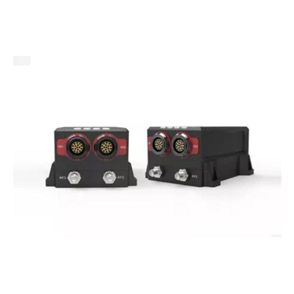
HGUIDE N380 Inertial/GNSS Navigator
The HGuide n380 is an incredibly small, lightweight, self-contained, all-attitude Inertial/GNSS Navigator designed for applications where robust, continuous position and attitude navigation data is required.
Modern navigation systems are expected to provide more than basic positioning. Industrial vehicles, marine platforms, surveying equipment, autonomous systems, and other mobile applications often need continuous information about position, velocity, attitude, and motion, even when operating conditions are challenging.
The HGuide n380 is designed for applications that require compact, lightweight, and continuous Inertial/GNSS navigation performance. By combining Honeywell’s i300 inertial measurement unit (IMU) with dual-antenna, multi-frequency and multi-constellation RTK capabilities, the system integrates inertial and satellite navigation data into a self-contained navigation solution.
A Compact Navigation System With Integrated IMU and GNSS
One of the defining characteristics of the HGuide n380 is its compact form factor.
Traditional high-performance navigation systems can require multiple components, external processing hardware, or complicated integration. The n380 takes a more integrated approach by combining inertial sensing and GNSS navigation functions in a single unit.
At the core of the system is Honeywell’s i300 IMU. The IMU provides measurements of angular rate and linear acceleration, while the GNSS subsystem supplies satellite-based positioning information.
The navigation algorithms combine these two data sources to produce a continuous navigation solution.
This architecture is particularly useful when an application needs both absolute positioning and attitude information rather than relying solely on a conventional GNSS receiver.
Why Inertial/GNSS Fusion Matters
GNSS is highly effective for determining position, but satellite signals can be affected by environmental conditions, obstruction, interference, and temporary signal degradation.
An inertial measurement unit provides a different type of information. Instead of relying on external signals, it measures the motion of the platform directly through inertial sensors.
By combining GNSS and IMU data, an integrated navigation system can maintain a more robust navigation solution across changing operating conditions.
The HGuide n380 therefore provides navigation information including:
-
Position
-
Velocity
-
Roll
-
Pitch
-
Heading
-
Angular rate
-
Linear acceleration
-
Time-stamped navigation data
This combination allows the navigation system to serve as a central motion and positioning source for equipment that requires continuous real-time data.
Dual-Antenna GNSS for Heading Measurement
Another important capability of the HGuide n380 is its dual-antenna GNSS configuration.
A conventional single-antenna GNSS receiver primarily determines position. With two GNSS antennas installed at a known baseline, the system can calculate heading from the relative position of the antennas.
This provides an important advantage for applications where heading information is required during system initialization or operation.
The n380 supports GNSS-based heading measurements and initialization in dual-antenna mode. This can reduce dependence on vehicle movement for initial heading determination and can be useful for platforms that need reliable orientation information before or during motion.
Multi-Frequency and Multi-Constellation RTK Capability
Positioning requirements vary between applications. For many industrial and professional systems, meter-level positioning may not be sufficient.
The HGuide n380 supports multi-frequency and multi-constellation GNSS with RTK capability. It can also accept RTCM3 GNSS correction data.
RTK corrections allow the navigation system to improve positioning accuracy when suitable correction services and GNSS conditions are available.
According to the supplied performance specifications, the system can achieve horizontal positioning accuracy of approximately 0.01 m at the stated RTK condition and approximately 0.025 m vertical positioning accuracy under the corresponding RTK condition.
The stated SBAS positioning performance is approximately 0.6 m horizontally and vertically.
These specifications make the n380 suitable for applications where navigation accuracy needs to be significantly better than standard standalone GNSS positioning.
Attitude Information for Mobile Platforms
Position alone does not fully describe the movement of a machine or vehicle.
For many applications, the system also needs to know how the platform is oriented. Roll and pitch information can be particularly important for vehicles operating on slopes, vessels experiencing movement, surveying platforms, and autonomous equipment.
The HGuide n380 provides pitch and roll information with the supplied performance specification indicating less than 0.08° at 1σ.
The combination of position, velocity, heading, roll, and pitch allows application developers to build a more complete understanding of platform motion.
For example, a navigation controller can use position to determine where the platform is, velocity to understand how it is moving, and attitude information to determine its orientation.
Navigation Performance in a Small Form Factor
A major engineering challenge in navigation equipment is balancing performance with size, weight, power, and integration complexity.
Large navigation systems may provide strong performance but are not always practical for compact platforms. At the other end of the spectrum, basic GNSS receivers may be small but lack the inertial and attitude capabilities required by more demanding applications.
The HGuide n380 is designed specifically around this balance.
Its small and lightweight architecture makes it suitable for equipment where available installation space is limited. At the same time, its integrated IMU, GNSS, RTK, and navigation processing capabilities reduce the need to assemble multiple navigation components.
This can simplify system architecture and potentially reduce integration work for equipment manufacturers.
Honeywell Inertial Technology
The n380 incorporates Honeywell’s i300 IMU and navigation technology.
A navigation system is only as reliable as the quality of the sensor data and algorithms behind it. Inertial sensors must be calibrated and compensated to minimize measurement errors, while navigation algorithms must continuously process sensor and GNSS information to generate a usable navigation solution.
Honeywell’s experience in inertial sensor development, calibration, compensation, and navigation algorithms is therefore an important part of the n380's value proposition.
The supplied product information also highlights Honeywell’s proven navigation algorithms for air, land, and sea applications, as well as its focus on reliability, dependability, and ruggedness.
Flexible Communication and Configuration
Different platforms have different interface requirements. A navigation system may need to communicate with a flight controller, vehicle computer, industrial controller, surveying system, or other embedded equipment.
The HGuide n380 provides multiple configurable communication ports, giving system integrators greater flexibility when connecting the navigator to other equipment.
Configuration flexibility is also useful when developing different product versions. Instead of requiring every customer to purchase the same feature set, the system can be configured around the functions required by the specific application.
This approach can help equipment manufacturers create more application-specific navigation architectures.
Potential Industrial and Professional Applications
The combination of compact size, inertial sensing, GNSS positioning, RTK, and attitude information gives the HGuide n380 a broad range of potential applications.
Autonomous Vehicles
Autonomous ground vehicles require continuous information about position, speed, and orientation. An integrated inertial/GNSS navigator can provide navigation data to the vehicle control system.
Surveying and Mapping
Surveying platforms can benefit from high-accuracy GNSS positioning combined with orientation and motion information. The dual-antenna capability can also provide heading information for platforms where orientation is important.
Marine Navigation
Marine platforms experience continuous movement, including pitch and roll. Combining GNSS positioning with inertial attitude measurements can provide a more complete navigation solution for vessels and marine equipment.
Industrial Mobile Equipment
Construction, agricultural, logistics, and other industrial machines increasingly rely on automated positioning and motion control. A compact navigation unit can provide the positioning and attitude data required by these systems.
Robotics and Autonomous Systems
Robotic platforms need accurate information about their position and orientation to plan and control movement. Inertial/GNSS fusion provides a practical navigation input for outdoor robotic applications.
Export Classification and System Integration
For international equipment manufacturers, export-control classification can also be part of the product selection process.
The supplied product information states that the HGuide n380 is not ITAR controlled and has an Export Control Classification Number (ECCN) of 7A994.
System integrators should still confirm the applicable export, import, end-use, and destination requirements for their specific project before shipment or deployment.
A Practical Navigation Solution for Space-Constrained Platforms
The HGuide n380 is designed for applications that need continuous and reliable navigation information without adding a large or complicated navigation subsystem.
Its combination of Honeywell’s i300 IMU, multi-frequency and multi-constellation GNSS, dual-antenna heading capability, RTK support, RTCM3 correction input, and integrated navigation algorithms gives developers a compact platform for demanding positioning and attitude applications.
For engineers selecting an Inertial/GNSS navigator, the key consideration is not simply positioning accuracy. Size, weight, attitude performance, heading initialization, communication interfaces, correction support, configuration flexibility, and overall system integration should all be evaluated together.
When these requirements are considered as a complete system, the HGuide n380 provides a practical approach to integrating high-performance inertial and GNSS navigation into compact professional platforms.
Reviews
There are no reviews yet.