
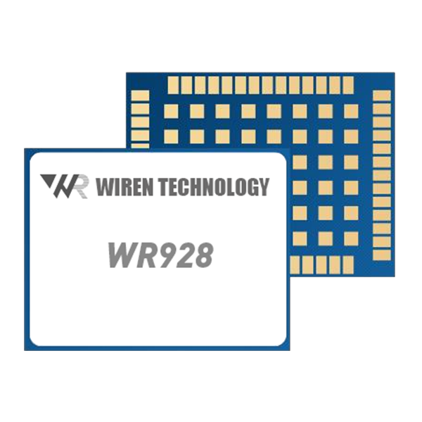
WR928 GNSS module
WR928 is a high-precision RTK GNSS Positioning and Heading Module ,that supports full constellation and full frequency bands, including BDS, GPS, GLONASS, Galileo and QZSS.
It can simultaneously track full constellations and full frequency bands such as GPS L1/L2/L5, BDS B1I/B2I/B3I ,GLONASS G1/G2, Galileo E1/E5a/E5b,QZSS L1/L2/L5.
It is designed for high-precision navigation and positioning applications such as surveying and mapping, precision agriculture, unmanned aerial vehicles (UAVs) and autonomous robots.
Modern positioning systems are no longer limited to basic GPS navigation. Industrial equipment, autonomous platforms, surveying instruments, robotics, and intelligent transportation systems increasingly require accurate positioning, fast signal acquisition, reliable tracking, and compatibility with multiple global satellite navigation systems.
A multi-constellation GNSS module can provide a practical foundation for these applications by receiving signals from different satellite systems and supporting multiple positioning modes. With support for GPS, BeiDou, GLONASS, Galileo, and QZSS, this type of GNSS module is designed for applications where positioning performance and system integration are both important.
Multi-Constellation GNSS Support
One of the key advantages of the module is its broad satellite signal compatibility.
The receiver supports:
-
GPS: L1, L2, L5
-
BeiDou: B1I, B2I, B3I
-
GLONASS: G1, G2
-
Galileo: E1, E5a, E5b
-
QZSS: L1, L2, L5
Supporting multiple constellations gives system designers more opportunities to obtain satellite observations in different operating environments. Instead of relying on a single navigation system, the receiver can work with signals from several constellations to improve satellite availability.
This can be particularly useful for industrial positioning systems, autonomous equipment, robotics, surveying devices, and other applications that require continuous positioning information.
Positioning Accuracy for Different Applications
GNSS accuracy depends heavily on the positioning technology being used.
In single-point positioning mode, the module provides an RMS horizontal accuracy of approximately 1.5 m and vertical accuracy of 2.5 m.
For applications requiring greater accuracy, DGPS can achieve approximately:
-
Horizontal: 0.4 m + 1 ppm
-
Vertical: 0.8 m + 1 ppm
RTK technology provides a significant improvement in positioning performance, with specified RMS accuracy of:
-
Horizontal: 0.8 cm + 1 ppm
-
Vertical: 1.5 cm + 1 ppm
These centimeter-level specifications make RTK particularly suitable for precision applications where conventional standalone GNSS positioning is not sufficient.
Potential applications include precision surveying, machine guidance, agricultural equipment, autonomous machinery, and other high-accuracy positioning systems.
PPP for Extended Positioning Applications
The module also supports Precise Point Positioning (PPP).
The specified PPP accuracy is approximately:
-
Horizontal: 5 cm
-
Vertical: 10 cm
PPP can provide high-precision positioning without relying on a conventional local RTK base station in the same way as traditional RTK workflows. Depending on the application and correction service available, this can provide another option for system developers working on wide-area positioning solutions.
The choice between standalone GNSS, DGPS, RTK, and PPP should ultimately depend on the required accuracy, correction infrastructure, operating environment, and system architecture.
Fast Time to First Fix
Position acquisition speed is another important factor for embedded navigation equipment.
The GNSS module has a specified cold-start time of ≤30 seconds and a hot-start time of ≤5 seconds.
Fast hot-start performance can be particularly valuable for systems that frequently restart, temporarily lose satellite visibility, or operate intermittently.
For mobile equipment and autonomous systems, reducing the time required to establish a valid navigation solution can help improve overall system responsiveness.
High Update Rate for Dynamic Equipment
The module supports a default data update rate of 50 Hz.
A high update rate is useful when the GNSS receiver is installed on moving platforms. Compared with low-frequency positioning updates, a 50 Hz output can provide more frequent navigation information to the host controller.
This can benefit applications such as:
-
Autonomous vehicles
-
Mobile robots
-
UAV systems
-
Machine control
-
Navigation equipment
-
Dynamic surveying platforms
-
Intelligent transportation systems
The actual performance of the complete positioning system will depend on antenna quality, satellite visibility, correction data, installation conditions, and host-system processing.
Heading and Velocity Information
The module provides more than position coordinates.
Its specified heading accuracy is approximately 0.1° RMS with a 1 m baseline, while velocity accuracy is approximately 0.03 m/s RMS.
Heading information can be valuable for systems that need to determine the orientation of a moving platform. This can be particularly useful in vehicle navigation, robotics, machine guidance, and other applications where position alone does not provide sufficient information.
The module also supports a 20 ns RMS 1PPS accuracy, making it suitable for systems that require accurate timing synchronization.
High-Sensitivity GNSS Tracking
Satellite signals can become relatively weak in challenging environments. Receiver sensitivity therefore plays an important role in determining how effectively a GNSS module can maintain satellite tracking.
The specified tracking sensitivity is -159 dBm, while capture sensitivity is -145 dBm.
High receiver sensitivity can support satellite signal acquisition and tracking in environments where signal conditions are less favorable. However, GNSS performance can still be affected by buildings, trees, multipath reflections, electromagnetic interference, antenna installation, and atmospheric conditions.
For demanding applications, the antenna and RF design should therefore be considered together with the GNSS receiver itself.
Compact Form Factor for Embedded Systems
Physical dimensions are an important consideration for OEM equipment designers.
The module measures approximately 21.0 × 16.0 × 2.6 mm, providing a compact form factor for integration into space-constrained electronic products.
This small footprint can make the receiver suitable for embedded applications where PCB space is limited.
Potential integration scenarios include:
-
Industrial navigation terminals
-
Surveying equipment
-
Robotics
-
UAV control systems
-
Vehicle positioning devices
-
Agricultural machinery
-
IoT tracking equipment
-
Autonomous systems
The compact design allows manufacturers to incorporate high-precision GNSS functionality without requiring a large dedicated navigation enclosure.
UART Interface and NMEA Compatibility
For embedded system integration, communication compatibility is just as important as positioning performance.
The module uses a UART interface, with a default communication speed of 115200 bps.
Navigation data is provided in the widely used NMEA 0183 format.
NMEA 0183 compatibility can simplify integration with existing navigation controllers, embedded processors, data loggers, and other positioning-related equipment.
Developers can therefore use standard navigation data structures to process information such as position, velocity, timing, and satellite-related parameters within the host system.
Low-Voltage Operation
The module operates within a supply voltage range of 3.0 V to 3.6 V.
This low-voltage operating range makes it suitable for integration with many modern embedded electronic systems.
For OEM developers, power supply design should still be carefully evaluated to ensure voltage stability and appropriate electrical protection under actual operating conditions.
Choosing a GNSS Module for Precision Positioning
When selecting a GNSS receiver for an industrial or commercial product, positioning accuracy should not be the only consideration.
System designers should evaluate several factors, including:
Satellite compatibility: Multi-constellation support can improve positioning availability.
Positioning mode: Standalone GNSS, DGPS, RTK, and PPP provide different accuracy levels and infrastructure requirements.
Update rate: Higher update rates are useful for dynamic platforms.
Sensitivity: Receiver sensitivity influences satellite acquisition and tracking performance.
Interface: UART and standard NMEA output can simplify embedded integration.
Size: Compact dimensions are important for space-constrained products.
Timing: Accurate 1PPS output can benefit systems requiring synchronization.
Environmental conditions: Antenna placement, multipath, interference, and satellite visibility should be considered during system design.
Applications of Multi-Constellation GNSS Technology
With support for multiple satellite constellations and high-precision positioning technologies, this GNSS module can be considered for a wide range of applications.
Typical areas include:
-
Precision agriculture
-
Land surveying
-
Industrial machine control
-
Autonomous vehicles
-
Robotics
-
UAV navigation
-
Construction equipment
-
Intelligent transportation
-
Asset tracking
-
Industrial positioning systems
-
Timing and synchronization equipment
For applications requiring centimeter-level accuracy, RTK functionality can provide a significant advantage over conventional standalone GNSS.
Conclusion
A modern GNSS module needs to provide more than basic latitude and longitude information. For professional positioning applications, satellite compatibility, positioning accuracy, acquisition speed, update frequency, sensitivity, timing performance, and embedded integration all contribute to the overall system capability.
This multi-constellation GNSS module supports GPS, BeiDou, GLONASS, Galileo, and QZSS, while offering multiple positioning modes including standalone GNSS, DGPS, RTK, and PPP. With RTK positioning accuracy specified at 0.8 cm + 1 ppm horizontally and 1.5 cm + 1 ppm vertically, a 50 Hz update rate, compact 21.0 × 16.0 × 2.6 mm dimensions, UART communication, and NMEA 0183 support, it provides a flexible positioning platform for a variety of embedded and industrial applications.
For OEM manufacturers and system integrators, the most important step is to match the GNSS module's technical capabilities with the actual requirements of the final product, including accuracy, mobility, correction services, antenna configuration, environmental conditions, and communication architecture.

Reviews
There are no reviews yet.